The Viral Acorn Creek Loop Hike - Acorn Creek Hike
- Annie Markuson
- Aug 19, 2025
- 6 min read

Updated: Aug 21, 2025
Best Hikes in Summit County, Colorado / Silverthorne, Colorado

Difficulty - MODERATE with approximately 1,200’ elevation gain
Distance - 4.5 miles round trip
This is hands down one of the best hikes in and around Summit County. From fields of bright colorful wildflowers, to lush mature forests, meadows, creek crossings, and insane panoramic views of the Nachu Range, formally called the Gore Range, hiking really doesn’t get much better than this!
This particular hike is known as the Acorn Creek Loop, however don’t be confused by the other information out there which for some reason highlights the Acorn Creek hike. The Acorn Creek Loop trail is not mapped online or at the trailhead (same trailhead at Acorn Creek) and it isn’t signed along the way, signed along the way, but is a far superior hike in my opinion. Added bonus...It’s not difficult to find and navigate the Acorn Creek Loop with the directions I will provide you below.

This hike became ‘Tik Tok’ famous in spring and early summer 2025 for very understandable reasons. Wildflowers, the views, the feeling like you're away from it all, creek crossings, the mixture of alpine environments from dense aspen and conifer forests as well as high alpine meadows....oh, and did I mention the incredible fields and variety of wildflowers? The downside of something becoming ‘Tik Tok’ famous is that it gets overly popular very quickly which leads to other problems such as overcrowded trailhead parking, busy trails, and a not so serene hiking experience. The Acorn Creep Loop hike going viral on Tik Tik was no exception. For these reasons I highly recommended avoiding this hike on weekends, and putting some thought into your timing to experiencing this joyful hike. Choose a week day, even better if that weekday is mid week (T-Th), arrive early to beat the crowds, or later in the afternoon or early evening to embark on your adventure as others are finishing up.
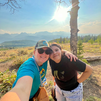
The kiddo I mentor through the local Mountain Mentors Program, Ruby, a soon to be 10th grader, just discovered her love of hiking this summer. She and I have been hiking weekly since and we timed this hike just right in our opinion! We decided to venture out on a Tuesday evening around 4:45 in mid-August, the week that most of the schools in the Denver area went back in session. There was shockingly only a single car and a motorcycle parked in the trailhead lot when we arrived! The only downsides with our timing were that with our unusually dry summer many of the wildflowers had wilted, which is not usually the case here on August 12th, and smoke from fires burning to the north and west of up blew in about 45 minutes into our adventure.


The trailhead is about 10 miles north of Silverthorne and the parking area is really quite large as well as easy to access. This area and these trails are also popular for people to ride their horses, so trucks pulling horse trailers could be present which tend to take up quite a bit of space in the lot. It’s important to know that if the parking area fills up and you choose to park alongside a county road you could be ticketed and fined or towed.
*There is no cell service at the trailhead or during the hike. Cell service becomes unreliable a couple miles north of Silverthorne so plan accordingly and make sure you have turn by turn driving and hiking directions noted somewhere that doesn't require cell service for you to access.
Trailhead Parking Lot Coordinates: 39°45'44.1"N 12.6"W, 10607
Directions to Trailhead Parking: Head north on US Highway 9 (from the Town of Silverthorne it will be about 10 miles before you turn off Hwy 9). Turn right onto Ute Park Road, continue straight onto Rodeo Drive (0.6 miles). The parking lot will be straight ahead right before Rodeo Drive takes a sharp right-hand curve.
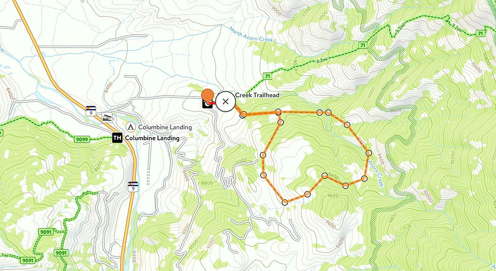
Acorn Creek Loop Hike
There is only 1 trail that departs from the north east corner of this parking lot. Start hiking on this trail! *Remember, Acorn Creek Loop trail is NOT mapped or signed, however with my simple instructions you should be able to easily navigate.
The Acorn Creek Loop hike is a “lollipop hike’, which combines an out and back hike with a loop at the end, resembling the shape of a lollipop.
When you start off you will hike on a mostly flat trail with property including a barn and a couple of windmills on your right and a meadow on your left. In about 5 minutes you will come to a “Y” in the trail. The spur to the left will be labeled “Acorn CRK #71” DO NOT GO LEFT! Instead you will head down the trail to your right. The trail on the right is not labeled. After you take your right hand-turn you will begin a gentle ascent and you will mostly be traveling through forested areas. It will continue climbing through the woods until you eventually come to another “Y”.


Barn and Windmills First 'Y' - Go Right Second 'Y' - Choice!
At the second “Y” you have reached the end or top of the lollipop stick. You know you are at the correct “Y” because you should see a large meadow in front of you flanked by wooded areas on both sides. Here you have a choice. You can either circle the lollipop clockwise or counter-clockwise.
Ruby and I went right, or counter-clockwise. I made this choice intentionally because this direction has an ascent is steeper, with many places offering up incredible panoramic mountain views and photo ops long the way (a great distraction), but a shorter overall distance to the apex where there are logs laid down under a few sparsely spaced trees, making for a great place to have a snack and take in the views. I knew Ruby would love knowing that once we got “to the top” her trek here on out would be a bit longer of a distance, but almost entirely downhill and also in a dense forest offering a lot of shade with several simple yet fun creek crossings along the way back down to the “lollipop stick”.
Left, or clockwise is a longer less intense climb, and a steeper and quicker descent. I think if I did this hike again I would actually complete the hike counter-clockwise, so I had my face, not my back, to the panoramic mountain vista views for a longer duration of the hike while I hiked down. Also, the uphill portion of this hike going clockwise would be mostly forested offering shade instead of enduring the hot sun while trucking up a steep sparsely treed meadow.


IMPORTANT TO NOTE: After the second “Y” there were a few different spots that looked like humans or animals made “cut throughs”. The rule of thumb we followed was to stay on the trail that looked more like the main trail or the trail that looked to be more traveled. This thought process lead us to make the correct decision every time.
If you hiked right or counter-clockwise don’t get fooled by the left hand turn that looks like an alternate route or shortcut when you reach the top of the meadow OR the left-hand turn going into a forested area across the trail from private property where you will see a fence gate where these owners can access the trail.
If you hiked left or clockwise there is a false trail on your right near the end of the first meadow. Stay to your left heading towards a more wooded area, not uphill through the meadow.
No matter which direction you choose to hike the lollipop you will get the uphill portion out of the way first followed by the downhill!
Once you complete the circle of the lollipop you will come back to the “Y” at the top of the lollipop stick. Once here you will head downhill, back the way you came up the trail, probably about ¾ of a mile back to your car.

Duration
This hike took Ruby and I about 3 hours. We did take many breaks on the up hill sections, none of which were long and 1 20 minute break at the apex for a snack and to take in the incredible views. I would have easily probably completed this hike in about 2.5 hours including breaks, but Ruby is still working on her stamina when more than a few hundred feet of elevation gain are included in a route.
What Now?
HAVE FUN! Take Lots of Photos! Hike at your own pace! And pack a backpack with lots of water, snacks, sunscreen, a first aid kit, and extra layers, just in case!


Comments